2.6 The Local Horizon
(Discovering the Universe, 5th ed., §1-6)
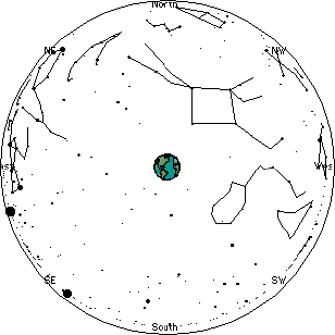
- To an observer on the Earth, only one half of the celestial
sphere can be observed at a time.
 As a result, in Atlanta
the sky appears roughly as shown at the right. As a result, in Atlanta
the sky appears roughly as shown at the right.
- The local horizon, often just called the horizon,
is the circle that divides the Earth and the sky from each other.
The compass directions north, south, east, and west are marked
along the horizon.
North will be underneath the north celestial pole.
When we face north, east is on our right and west is on our left.
- Another coordinate system that is commonly used to locate
objects in the sky is the altazimuth system, which is
based on the local horizon.
The altitude of an object is the angle between it and
the horizon.
The horizon has an altitude of 0° and the zenith has an altitude
of 90°.
The azimuth of an object is the angle between it and north,
measured clockwise along the horizon.
North has an azimuth of 0°, east has an azimuth of 90°,
south has an azimuth of 180°, and west has an azimuth of
270°.
- The local meridian, often just called the meridian,
is a semicircle that passes through the celestial poles and the
zenith.
Question: the local meridian
is a projection onto the celestial sphere of what previously
described item on the Earth?
- Note that the horizon, zenith, and
meridian are fixed relative to the observer; hence the stars
and sun will move past them with time.
Question: what happens to
these items when the observer moves to a different location on
the Earth?
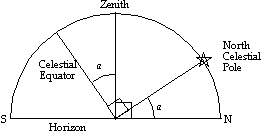 Simple geometry shows
that the angle between the zenith and the celestial equator (i.e.
the zenith's declination) must also be the angle between the
north celestial pole and the north horizon. Simple geometry shows
that the angle between the zenith and the celestial equator (i.e.
the zenith's declination) must also be the angle between the
north celestial pole and the north horizon.
Since the zenith's declination is equal to one's latitude, Columbus
was always able to determine his latitude when he crossed the
Atlantic Ocean by measuring the altitude of Polaris.
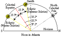 During
the summer, the Sun is located near the summer solstice, north
of the celestial equator. During
the summer, the Sun is located near the summer solstice, north
of the celestial equator.
In Atlanta, it therefore appears high in the sky at transit,
33.7° - 23.5° = 10.2° away from the zenith.
- During the winter the Sun is near the winter solstice, south
of the celestial equator.
In Atlanta, it therefore appears low in the sky at transit, 33.7°
+ 23.5° = 57.2° away from the zenith.
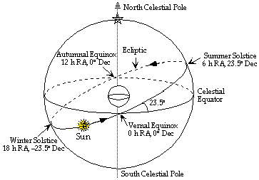
- At a latitude of 23.5° N, the tropic of Cancer,
the Sun just reaches the zenith on the summer solstice.
At 23.5° S, the tropic of Capricorn, it just reaches
the zenith on the winter solstice.
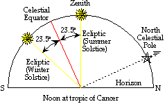 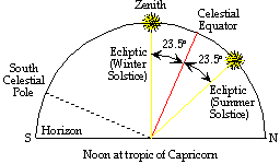
Between these latitudes (the tropics), the Sun crosses
the zenith twice during the year.
Tropic is from the Greek for "turning", again describing
the Sun's motion at the solstice.
Cancer and Capricorn are the constellations where the Sun is
located at the solstices (or rather where it was located in 500
B.C...).
 The closer the Sun is to the zenith, the
more concentrated its light is on the Earth's surface, so the
more energy it transfers. The closer the Sun is to the zenith, the
more concentrated its light is on the Earth's surface, so the
more energy it transfers.
This is why summer is warmer and winter is colder, and why the
tropics are warm year round.
|


 Recall
that the Earth's rotation axis is a line that passes through
the geographic poles (the North and South Poles),
and the center of the Earth.
Recall
that the Earth's rotation axis is a line that passes through
the geographic poles (the North and South Poles),
and the center of the Earth.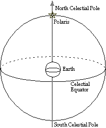 We describe the
celestial sphere using a similar geographical notation:
We describe the
celestial sphere using a similar geographical notation: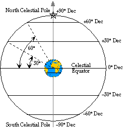 Declination
corresponds to latitude, and is measured in the same way, but
relative to the celestial equator (0° dec).
Declination
corresponds to latitude, and is measured in the same way, but
relative to the celestial equator (0° dec).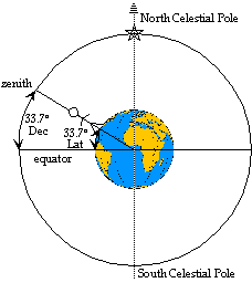 For any position on the surface
of the Earth, the point on the celestial sphere that is directly
overhead is called the zenith.
For any position on the surface
of the Earth, the point on the celestial sphere that is directly
overhead is called the zenith.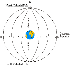 A star's
position along a circle of constant declination is described
by a second number called right ascension.
A star's
position along a circle of constant declination is described
by a second number called right ascension.
 Although the stars are fixed
relative to each other, the Sun moves relative to the stars.
Although the stars are fixed
relative to each other, the Sun moves relative to the stars.